Latitude and Longitude are two of the most important coordinates used to specify the location of a place on a geographical map.
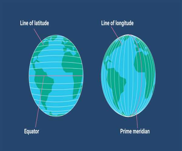
Latitude is the angular distance measured north or south of the equator. It is measured in degrees, minutes and seconds and is written in the form of a degree with the symbol °. For example, the equator is 0°, the North Pole is 90° north, and the South Pole is 90° south.
Longitude is the angular distance measured east or west of the prime meridian. It is also measured in degrees, minutes and seconds and is written in the same format as latitude. The prime meridian is the meridian that passes through Greenwich, England, and is 0°.
Together, these two coordinates create a grid pattern that divides the earth into 360° of latitude (north-south lines) and 180° of longitude (east-west lines). This grid, also known as a graticule, is used to locate any place on earth with high accuracy.
Usage
- Latitude and Longitude are useful for mapping and navigation because they help pinpoint a specific location on the planet. Latitude is measured in degrees, minutes and seconds and is written as a pair of numbers, such as 32° 18' N. Longitude is measured in the same way, but it is written as a single number, such as 122° 4' W. The two coordinates together to form a precise numerical identifier for any location on the Earth.
- Using latitude and longitude can be helpful for a variety of purposes, such as finding the distance between two points, determining the direction from one point to another, or plotting a route on a map. Geographers and navigators use latitude and longitude to determine the exact location of features on the Earth’s surface. For example, if you’re planning a trip, you can use latitude and longitude to determine the driving distance and route between two cities.
- Latitude and longitude can also be used to determine the local time at any given location. By using the time zones associated with a particular location, you can easily determine the local time, even if you’re in a different time zone.
- Finally, latitude and longitude can be used to identify and describe regions on the Earth’s surface. By plotting a region’s latitude and longitude coordinates on a map, you can quickly determine its boundaries. This can be helpful for determining the size of a region or for understanding how different regions interact with one another.
In short, latitude and longitude are essential coordinates for any geographic or navigational purpose. By understanding how they work and how to use them, you can make navigating the world easier.